Demolishing Informal Settlements in Khartoum and Al-Jazirah: A War Within a War
Agencies – Atar Team
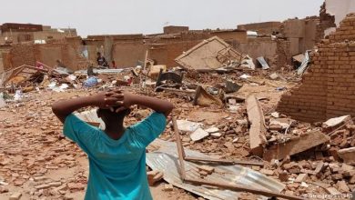
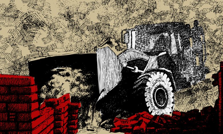
In mid-March 2025, residents of the Al-Ezba neighborhood in Bahri city were caught off guard when bulldozers and heavy machinery suddenly moved in, demolishing their homes—furniture and belongings still inside—flattening them to the ground without prior notice.
In early July 2025, the Khartoum State Land Protection Agency announced the completion of demolitions targeting “informal encroachments” in Blocks 18 and 19 of Abu Saad, Omdurman. The agency’s director, Abdelaziz Abdullah, stated that the operation—carried out by regular forces, prosecutors, engineers, and administrative staff—removed 806 houses, in line with state directives to eliminate “informal housing” due to “security threats and negative phenomena associated with it.”
On July 12, a joint task force from East Nile locality demolished informal housing in Souq 4, Baraka district (known locally as “Carton Kassala”).
On July 21, the official Khartoum State platform reported that Defense Minister Lt. Gen. Hassan Daoud Kabroun had formally taken possession of his plot in Block 19, Abu Saad, through a representative. Survey markers were placed in the presence of land surveyors and relevant officials from the Ministry of Urban Planning.
According to the Land Protection Agency, Khartoum State had completed 60% of its informal housing clearance plan by June 25, part of a comprehensive inventory and demolition program across all localities. This included areas in East Nile (Khayrat), Block 19 in Halfaya, Block 13 in Matari Halfaya, Al-Ezba in Bahri, as well as Mandela, Gubosh in South Khartoum, and areas as far as Jebel Aulia.
Beyond the War
The challenge after the war is not merely halting forced displacement, but redefining citizenship, urban planning, and the legal recognition of “kanabi” residents—agricultural labor communities—who form part of Sudan’s civil society and have rights. This includes halting all forms of structural clearance, launching an independent international investigation into abuses committed against these communities, and integrating them into housing, development, and employment programs. Justice is not measured by the height of buildings, but by the dignity of the people living in them.
A War on the Informal
Successive Sudanese governments have long sought to eliminate informal housing in the capital, with multiple waves of clearance campaigns. This time, however, the effort came under the shadow of war. Khartoum and its sister city, Wad Madani, became battlegrounds between the Sudanese Armed Forces (SAF) and the Rapid Support Forces (RSF) during the April war. Months after the army regained control, authorities turned their sights on informal settlements.
Appearing in military attire on Blue Nile TV, Abdelaziz Abdullah Ahmed, Director of Khartoum State’s Land Protection and Violations Removal Agency, described the recent anti-informal housing campaign as “part of the current war,” and as a means of restoring land rights to holders of title deeds who had been waiting decades without receiving their plots. He claimed that residents removed from East Halfaya’s Block 19 had been compensated earlier but never relocated, and that in Al-Ezba, structures encroaching on roads, schools, and public spaces were removed because the area was already planned. He confirmed that police, armed forces, and prosecutors took part in the demolitions as part of a state-wide plan.
Engineer Waleed Abdullah Ahmed Ali, head of the Bahri branch of the agency, said their focus had been on removing “security and social risks for citizens” to prepare the capital for residents’ return “so they can live normally.” He said commercial structures west of the Jili oil refinery were cleared, blaming their growth on “land mafias” and illegal sales, and described Al-Ezba’s informal housing as a security threat. He warned residents without official ownership documents to remove their belongings from targeted areas.
The Bulldozers at Work
The demolition of homes has sparked deep public resentment and criticism of the government’s timing—destroying houses and markets immediately after war—raising questions about reconstruction priorities, compensation, and the complex social consequences of mass displacement.
One East Nile resident told Ater his father had purchased a plot from local committees and the village chief before the war, with promises of future services. They fled to Gedaref at the war’s onset and returned after the army regained Khartoum, only to find their neighborhood classified as a “social incubator” for the RSF. In May, the area was officially labeled as “informal housing” and demolished. “Our houses were torn down over our heads,” he said.
Abdo Ishaq, a resident of Al-Ezba, described the aftermath as “tragic.” He said bulldozers, escorted by armed personnel in military uniforms, razed his home and those of neighbors who had lived there for over 30 years—without prior warning. “People were left homeless in the open; their belongings buried under the rubble,” he said.
Hashem Osman, from Old Bahri, explained that “Al-Ezba” historically referred to a wide area east of Bahri’s main market, home to Al-Ezba School and Mosque, and extending to areas known as “Al-Ahamda” with temporary huts and mud houses inhabited by industrial workers. The area, known as “Ezbat al-Tarawa,” was demolished in the 1990s under the 1991 master plan led by then-minister Sharaf al-Din Banaga, amid rising migration and displacement. The community was moved eastward, near upscale Kafouri.
Merchants at Jili refinery market told Ater their licensed shops had been demolished despite being legally recognized by Bahri locality authorities. Trader Ali al-Mahi demanded substantial compensation for “shops that were unjustly leveled to the ground, and for the land itself.”
Colonial Legacies in Urban Planning
Architect Waleed Mubarak al-Reeh noted that Khartoum, founded in 1821 by the Turco-Egyptian administration, was not designed as a civic capital but as a military outpost on the Blue Nile, chosen for strategic rather than residential or economic reasons. After its reconstruction in 1898 under British rule, the city became a textbook example of colonial urban planning—segregated by class and ethnicity, laid out in a grid system. The city center was reserved for British authorities, while Sudanese residents were pushed to peripheral districts such as al-Diyoum and Hilla Hamad. British engineer McLean once remarked on the dire sanitation conditions in Sudanese homes, particularly in “the Diyoums,” where there were no indoor toilets and open defecation was common. He suggested physically walling off these neighborhoods from the planned city.
Instead, authorities opted to build the central railway station—physically separating native districts from colonial Khartoum. The rail line became not just infrastructure, but a hard urban boundary between two worlds: that of the colonizer and official, and that of the Sudanese laborer.
An Investment-Driven Policy
Al-Reeh argued that even after more than a century and despite advancements in Sudanese engineering, Khartoum still suffers from colonial-era class-based planning. Official housing classifications—first, second, and third class—persist, reinforcing inequality. First-class districts enjoy larger plots and better services; third-class districts, often on the periphery, remain poorly serviced.
Recent land policies, he said, focus on investment and pushing out low-income communities rather than providing affordable housing or upgrading informal areas. “Khartoum is not just a city that grew informally,” he said, “it is a mirror of urban policies steeped in discrimination. Breaking that requires more than new roads or tall towers—it means redefining the city as a space of justice and participation. It’s time to shed the colonial urban model and build a capital for all Sudanese—not just for a privileged few.”
Quoted from Atar