Reports
Geography of Flooding in Sudan
Sudan Events – Agencies
“Ked” is a Nubian word that means “drowning.” It has been used frequently in Nubian poetry to describe major drowning events, such as the flooding of Halfa after the construction of the Aswan High Dam. For example, the Nubian poet Maki Ali Idris used the word extensively in his poem about the dam, where he narrates what the Kajbar Dam might do in drowning the surrounding Nubian villages. “Ay Kedoso” means “I am drowning.” Perhaps every dam is a “Ked.”
At 2 AM on August 25, after heavy rains the previous day, the pressure increased on the body of the Arbaat Dam in the Red Sea State, which holds less than 5 million cubic meters of water, while its total capacity is 16 million cubic meters. The accumulation of silt over the years since its construction around 20 years ago has increased sedimentation rates. According to geologist Karam Al-Din Hussein, the collapse of the Arbaat Dam was not surprising to those familiar with its size and the amount of silt it deposits each year, especially considering the difficulty of repairing and dredging it.
The Arbaat River originates from the mountains northwest of Port Sudan and flows northward, forming a small delta. This river is known to be the second in water yield after the Barka River. This fact is crucial as the river’s upper sources flow from a mountain range with elevations of up to 1,500 meters above sea level. The range includes two prominent peaks: Bawati Mountain, with an elevation of 1,726 meters, and Oda Mountain, with an elevation of 2,246 meters.
The disaster caused by the collapse of the Arbaat River Dam led to the collapse of 148 wells in the “Adloeb” area, while only one well remained in the Arbaat agricultural area. This well produces about 40 tanker loads of water daily, equivalent to 160 tons. According to Dr. Ahlam Abdelrasoul, an official from the Federal Ministry of Health and the Rainfall Emergency Committee, there have been four confirmed deaths, and 122 people were injured. Another source from local leadership said that about 235 people were assisted. The Takweili Health Center received 30 cases of fractures and injuries, despite facing a shortage of services. Livestock losses totaled 300 heads, in addition to losses for orchard and farm owners.
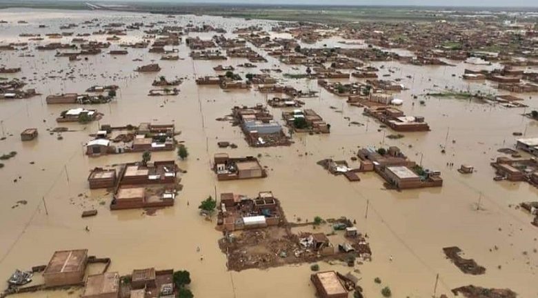
According to an update prepared by the United Nations Office for the Coordination of Humanitarian Affairs (OCHA), local authorities stated that the death toll from the dam collapse could exceed 30 people, and about 70 villages around the Arbaat Dam were affected by the sudden floods, with 20 villages destroyed. Representatives of the Red Sea State government, the Emergency Management of the Federal Ministry of Health, and the government’s Humanitarian Aid Commission were unable to reach the villages on the eastern bank due to road cuts.
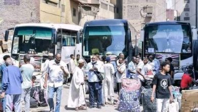
Authorities reported that out of the 13,000 families (about 65,000 people) living west of the Arbaat Dam, the homes of about 10,000 families (50,000 people) were destroyed or damaged.
Different Autumn, Different Disasters
The Red Sea State experienced varying rains during July and August. During this time of year, summer reaches its peak, and temperatures and humidity increase together. Given the Red Sea’s topography, rivers flow from the hills to the coastal plain, forming deltas. Most of these rivers flow during winter, with some reaching the sea and others forming deltas in low-lying areas.
Village Deaths Missing Persons
Kelseeb Village 3 1
Adloeb Village 4 2
Al-Mahnab, Tabu, and AgoykanInjuries and missing persons
Rabaaite Area1 child (9 years old)
Kisbiyai Not recorded Not recorded
Overall, more than 40 villages in the Arbaat area were affected. The table above reflects the fatalities reported by an ATR correspondent.
Geologist Hussein stated, “The Arbaat crisis cannot be separated from the Barka River. Once we realize that the purpose of the dam was to provide water, we will understand that there is a need to reconsider the Arbaat and Tokar disasters as a solution to a problem that Sudanese governments have overlooked since the 1970s. The annual water yield of the Barka River is about 48 million cubic meters; the water that falls on the northwestern mountains of Port Sudan is shared between the Oku River and the Arbaat River. As mentioned earlier, the Oku River flows northward toward the Halayeb Triangle.”
Engineer Ayman Al-Bushra enumerated other problems in the Arbaat River besides siltation. One of these is the construction of the dam in a highly sloping area, leading to significant silt deposition. Additionally, its proximity to the sea increases the speed and strength with which it sweeps through farms and villages, especially with 5 million cubic meters of stored water. This situation is akin to having a 5-ton bomb and pushing it toward the coastal plain.
Barka: Tokar’s Annual Curse
Every year, the Barka River carries fertile silt from “Lalu” to “Kabsa,” making Tokar a yet-to-be-discovered land of promise. Due to unbalanced development policies and government corruption, mesquite trees have replaced cotton and almonds, leaving only land annually planted with tomatoes, which often end up as animal feed.
Tokar has turned into a forgotten city after cotton prices used to be determined via phone calls to London. According to Hudab, a researcher in the heritage of eastern Sudan, Tokar symbolizes cotton cultivation and development and signifies the misery that Sudanese state institutions have reached.
The Barka River flows from July to September, with intermittent floods lasting from one to two days, with up to 20 floods annually. The river’s annual water yield ranges from 200 million to one billion cubic meters, with an average yield of about half a billion cubic meters annually.
The 2024 flood caused the deaths of about 14 people, which may increase, according to Saleh Hassan, an assistant doctor in Tokar. Ahmed Ibrahim, a volunteer and resident of Tokar, stated that the damage in the city affected 100% of the area from the first neighborhood to the tenth, with 95% of homes collapsing.
The market in Tokar was also affected, though not as severely as homes and neighborhoods. In addition to the fatalities, Ibrahim said many people are missing, but they have not yet been counted.
Ibrahim Mustafa, a political activist in the city, reported that at 10 PM on Sunday, August 25, water invaded the city from three directions at a very high level, surpassing the flood of 2020. He added that “more than 20,000 homes completely collapsed, and a number of shops and bakeries partially collapsed. Meanwhile, citizens are stranded on bridges, there is no safe drinking water, all hospitals are closed, and there have been 13 reported deaths, with an unknown number of missing persons.”
Amin Al-Sheikh, the executive director of Tokar locality, described the humanitarian situation in the city as catastrophic. He told ATR that “the situation is extremely dangerous after the Barka River flood swept through Tokar from all directions, leading to the complete destruction of service infrastructure and rendering it inoperable. A large portion of the city has collapsed, isolating it completely from the roads connecting it to surrounding areas.”
With no strategic food stockpiles and services halted, the suffering of citizens trapped inside Tokar is worsening. Residents need urgent intervention to deliver food and shelter supplies to thousands of stranded people, who are difficult to reach due to road closures leading to the city.
Returning to the relationship between the Barka River flood and the collapse of the Arbaat River Dam, there is a need to rethink the essentials on which the Arbaat Dam was based, which has already reached the end of its lifespan. Certainly, no rock dam in the world can last more than half a century.
In a dialogue session organized by ATR magazine via Google Meet, which included seven geologists from various Sudanese universities, geophysicist Ahmed Muhammad stated: “If we look at the general condition of dams in the Red Sea State, we find that their lifespans range between 15 to 20 years, and no dam, even those without significant silt deposition issues, can last beyond this time.”
ATR posed a question to the session participants about how the collapse of the Arbaat Dam could be turned into an opportunity to stop the Barka River flood. Most opinions suggested reconsidering the necessities on which the Arbaat Dam was established and how its collapse could be used to promote development in the area, especially since it is fertile agricultural land that can provide livelihoods for many, in addition to revitalizing the local market. They pointed to the study conducted by “Ruhr Rhine” in 1988, which aimed to transfer water from the Barka Basin.
They Perished
The Indian monsoon trough gives clouds the ability to cross hills and move toward the land. The Northern and Nile River states have been affected by waves of floods and rains recently. Examining the rain and cloud distribution map that passed through some parts of the Nile River State, the southwestern parts of the state were more affected than the north. The rivers that had disappeared for decades have resumed their flow, and most parts of the Al-Inqaz neighborhood, as well as the railway and the reserve in the city of Karima, were destroyed by the floods.