Why are the Rapid Support Forces desperate to defend the Soba Bridge?
Report – Al-Nour Ahmed Al-Nour
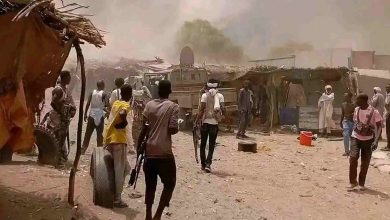
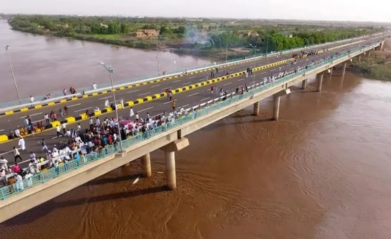
The clashes between the Sudanese army and the Rapid Support Forces have intensified after nearly 22 months of fighting in Khartoum, in the southern, eastern, and central parts of the capital. Meanwhile, these forces are desperate to maintain control of the Soba Bridge, which connects Khartoum to the eastern Nile, in order to avoid being surrounded and isolated from each other between the state’s cities.
On September 26, the army launched a large-scale military operation in the three cities of Khartoum State, using the White Nile, Fatihab, and Halfaya bridges to target the Rapid Support Forces. It took control of important positions in central Khartoum, marking a significant shift.
There are 10 main bridges connecting the three cities of the Sudanese capital — Khartoum, Omdurman, and Khartoum Bahri — across the Blue Nile, White Nile, and the Nile River.
Khartoum is connected to the East Nile by the Soba and Manshia bridges, both under the control of the Rapid Support Forces. It is also linked to Khartoum Bahri by the Blue Nile, the “Kober” bridge, and the “Al-Mak Nimer” bridge.
The White Nile, Fatihab, and Jabal Awlia bridges separate Khartoum from Omdurman, while Khartoum Bahri is connected to Omdurman by the Halfaya and Shambat bridges.
The Sudanese army and the Rapid Support Forces have been engaged in fierce fighting for the past three days over control of the strategic Soba Bridge, which links the western part of Khartoum to the eastern side.
On Tuesday, the Chairman of the Sovereign Council and Commander-in-Chief of the Armed Forces, Abdel Fattah al-Burhan, during his visit to the Wad Abu Saleh area in East Nile, stated that the army was close to gaining control of the Soba Bridge.
Where is the Soba Bridge located, and when was it built?
The Soba Bridge is located on the Blue Nile, south of Khartoum, linking the Soba areas (East and West) to Khartoum and East Nile. The concrete span of the bridge is 571 meters long, and it is 27 meters wide, with three lanes in each direction.
The construction of the bridge began in December 2012, and it was opened in July 2017, at a cost of 40 million dollars.
The western approaches of the bridge extend 3,450 meters and meet the Wad Madani road, the capital of the Gezira State, while the eastern approaches extend 2,300 meters and meet the Al-Aylfoun road, leading to the Hantoub Bridge on the eastern side of the Gezira State.
The bridge is part of the ring road that connects the cities of Khartoum as part of the state’s plan to link national and circular roads. It is used by passenger buses and trucks traveling from Port Sudan to the capital.
What is the military significance of the Soba Bridge?
Military and security expert Salem Abdullah considers bridges to be strategic positions in battle, as they provide communication and supply lines across the Blue Nile, White Nile, and the main Nile, connecting the three cities of Khartoum. Control over the bridge can mean a lot for the warring parties.
In an interview with Al Jazeera, the expert explained that the bridge is strategic for the Rapid Support Forces because it connects them to East Nile and enables movement, maneuvering, and supply in this area. The army’s control of the bridge would significantly tighten the siege on these forces.
What does the loss of the bridge mean for the Rapid Support Forces?
A military source, in a statement to Al Jazeera, believes that the future of the war in the capital largely depends on the ongoing battles. If the army manages to regain control of the Soba Bridge — which is considered a matter of time — it would deprive the Rapid Support Forces of an important passage between the eastern and western Blue Nile, and this would change the course of the war.
According to the military source, who requested anonymity, control over the bridge would isolate the Rapid Support Forces in besieged pockets, cutting off any supply routes.
The same source revealed that the Rapid Support Forces in the Soba area are surrounded from the south by the advancing forces from the eastern Gezira State and Al-Aylfoun, from the north by the army, which has reached the Marabe’ al-Sharif area, and from the east by the Blue Nile. The only remaining options for the forces are either death or retreating westward toward Khartoum and from there to Jebel Awlia toward western Sudan.
The fate of the Rapid Support Forces in East Nile, where active operations are underway and the army has reached deep into the area, is tied to the Soba Bridge. The Manshia Bridge, which also links Khartoum to East Nile, could be neutralized at any time, as the army has approached its eastern entrance and could take control of it by fire.
The spokesperson stated that not withdrawing from the area means suicide for the Rapid Support Forces, as they have no access points or supply routes left.
How does the Rapid Support Forces view the army’s advance toward the Soba Bridge and East Nile?
In a sharp tone, the head of the Rapid Support Forces’ Orientation and Services Department, Hassan al-Turabi, denied reports of his forces retreating in Khartoum, calling these news rumors spread by “enemy and remnants” media to mislead public opinion.
In a press conference broadcast on loyalist platforms, Hassan al-Turabi stated on Thursday that “the clear truth is that our forces have successfully repelled enemy attacks on all fronts, and our forces remain cohesive and strong, continuing to advance in all positions.”
A spokesperson from the Rapid Support Forces’ media office told Al Jazeera that they are still holding onto all critical and important positions in Khartoum, and the confrontations around them will be a matter of “breaking bones,” whether at the Soba Bridge or elsewhere.
Source: Al Jazeera